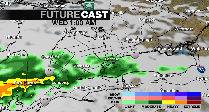
A rainfall warning has now been issued for the City of Toronto, with the remnants of Hurricane Beryl expected to result in torrential downpours overnight and into tomorrow.
Environment Canada issued the warning on Tuesday afternoon. It replaces a special weather statement that was previously in effect.
The weather agency says that there could be rainfall totals of 40 to 60 millimetres across most of southern Ontario as a result of the storm, with higher amounts possible in some areas.
“Although confidence in the exact track of the weather system remains somewhat uncertain, these type of systems in the past have given very high rainfall rates in torrential downpours,” the warning states. “Rainfall amounts will likely be highly variable across the region, and some areas may receive in excess of 60 mm.”
Beryl made landfall in Texas as a Category 1 hurricane on Monday after leaving a path of destruction in the Caribbean over the weekend.
The storm has weakened significantly since making landfall but could still bring torrential rain to most of Ontario.
The rain is forecast to begin at around 1 a.m. with some of the heaviest bands possible during the morning rush hour on Wednesday.
“It looks like the heaviest rain will be in the Lake Huron area and Eastern Ontario but we could pick up 20 to 40 mm of rain in a very short period of time (in the GTA) and that will cause some localized ponding and flooding,” CP24 Meteorologist Bill Coulter warned earlier on Tuesday morning. “So be aware of that tomorrow morning and maybe give yourself some extra time. By the time Thursday is done the whole system and the cloud goes with it, setting up a really nice weekend. The challenge will just be dealing with it, mostly tomorrow morning.”
 The remnants of Hurricane Beryl are shown arriving in the GTA on Future Cast radar. (CP24)
The Toronto and Region Conservation Authority has issued a flood watch ahead of the arrival of the system and is warning that “all shorelines, rivers and streams within the GTA should be considered dangerous.”
The authority has said that due to the rainfall totals there is also “potential for widespread flooding” within its jurisdiction on both Wednesday and Thursday.
“Ground conditions are not saturated, however, will likely become saturated throughout the TRCA jurisdiction after tomorrow (Wednesday) morning’s rainfall event. As such, all watercourses and water levels within TRCA watersheds are expected to rise beginning early tomorrow (Wednesday) morning into Thursday due to the forecasted rainfall,” the flood watch states.
In its warning Environment Canada said that the heaviest bands of rain could total between 20 and 40 millimetres per hour.
The storm, however, will not carry significant winds.
The weather agency says that winds will only reach about 20 km/h overnight and 30 km/h on Wednesday
“As it gets caught up in the jet stream it loses some of its tropical characteristics, the circular shape, and it is being more stretched out as it flows up the Ohio River Valley and right into the lower Great Lakes region,” Coulter said. “It will arrive around 1 a.m. overnight and because it has been stretched out there is quite a long period of some heavy rain. Most of that will come after midnight tonight, through the morning rush and into mid-day.”